by State Senator Mary Duvall
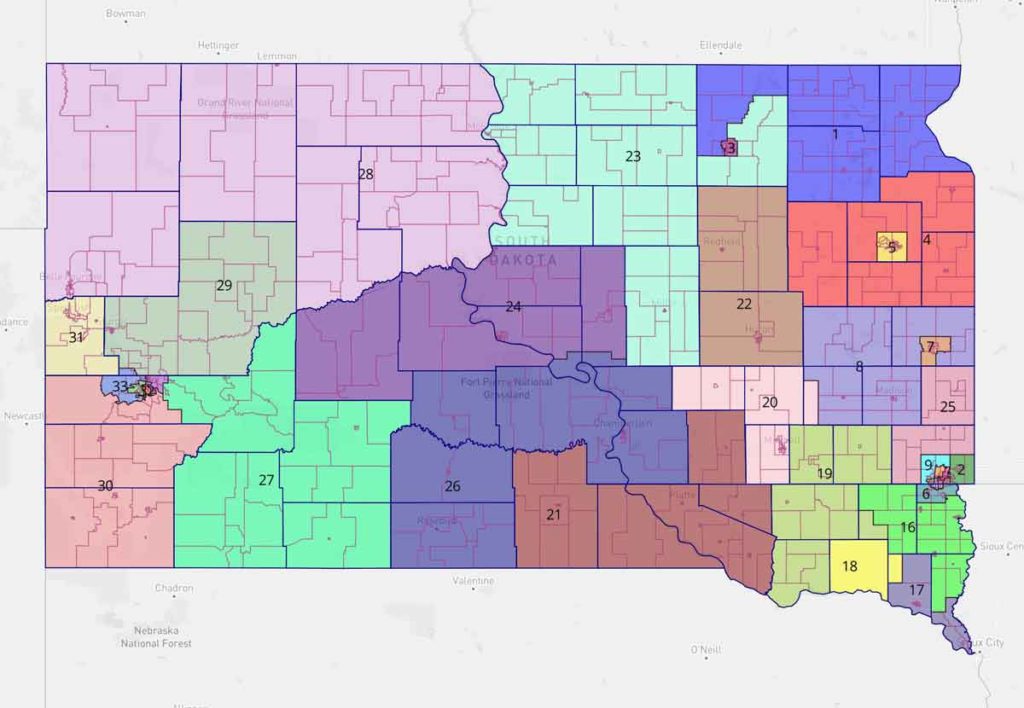
The Senate Legislative Redistricting Committee, on a 5-2 vote, is recommending the “Blackbird 2.0” map proposal for the full Senate to consider when it convenes for a special legislative session on redistricting in November. The new version of the map reflects changes to the original Blackbird map based on public feedback, conversations with House colleagues, and ideas offered in other maps.
Legislative redistricting has been called perilous work. It is a process that will not make everyone happy. Our Senate proposal reflects a commitment to coming up with a map that is fair for South Dakota, based on census data to develop districts that are as nearly equal in population as is practicable, that are contiguous and compact, and that respect political boundaries and communities of interest.
Under the new map, areas of Hughes and Hyde counties that are part of the Crow Creek Indian Reservation would be included with the rest of the reservation in District 26. An earlier version of our map kept Hughes and Hyde counties whole but included part of Tripp County to help meet population goals in District 26. The new map keeps all of Tripp County in District 21.
We changed the map to keep Fall River County whole, rather moving some of the eastern precincts to District 27. We propose adding part of eastern Pennington County to District 27 to get us closer to our population goals while at the same time adhering to the Voting Rights Act.
Based on public input and feedback from House members, we revised the map to put all of Turner County, except for one precinct needed to meet population requirements in the neighboring district, into a district with southern Lincoln and part of Union to form a rural district south of the Sioux Falls metro area. We propose keeping Clay County whole with the exception of one precinct needed to meet population needs in Yankton County. We revised the map to keep the entire city of Watertown within one legislative district, aligning the rest of Codington County with Grant, Deuel, Hamlin, and Clark counties to comprise a rural legislative district.
We received many comments about the very southeastern part of South Dakota, encompassing Clay and Union Counties. Much of the public feedback expressed concern about splitting the town of Vermillion among three different legislative districts. Our proposal puts Clay and southern Union County back together, as they were in the 1970s and 1980s, and keeps Vermillion in one district.
Brown County residents expressed a desire to be split between no more than two legislative districts. As we looked at map proposals based on this request, the results showed the adjoining legislative District 23 stretching from Pollock to Wessington Springs, splitting Beadle County along the way. Our new map proposes adding part of rural Brown County to District 23, to meet population requirements.
The Sioux Falls area generated mixed comments from the public. One thing we heard early in the process is that the current Districts 9 and 25 look “gerrymandered.” We are proposing a map that joins the agricultural area of northern Minnehaha County with Moody County, while the area encompassing Brandon and the growth in eastern Sioux Falls would have its own legislative district. We also propose that District 9 encompass northwest Sioux Falls and the immediate townships surrounding Sioux Falls where the city is expected to see rapid growth.
Our revised “Blackbird 2.0” map is available for viewing online at sdlegislature.gov under the 2021 Redistricting tab. If you have questions or comments, please feel free to reach out to any member of the Senate redistricting committee.
About The Author
You may also like
-
The Pandora Papers: Puff and Point by Thomas E. Simmons
-
Guest Column: How will you wield your wand? by State Senator Jessica Castleberry
-
Guest Column: In South Dakota, students need to learn Native American history, and they also need to learn how our tribal communities fit into the state today.
-
And now for something different!